A history of flooding and our increasing vulnerability
Olympia is blessed to be in such a beautiful location. Nestled at the very southern end of Budd Inlet in Puget Sound, Olympians have long enjoyed a rich maritime history and deep connection with the water. The tidal variations we experience at our location in Puget Sound are significant and especially dramatic during “King Tides” each year. They are a regular reminder of the real vulnerability we face with sea level rise.
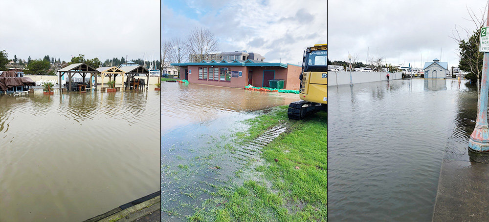
That was certainly the case in January of this year. On January 7, 2022, a 17.9-foot tide in Budd Inlet collided with heavy runoff in the Deschutes River and resulted in substantial flooding in Heritage Park. Due to low barometric pressure, the tide came in 1.5 feet above the predicted tide of 16.4 feet. Olympia Public Works and State Department of Enterprise Services crews were prepared and worked hard to hold water within the park and avoid broader flooding. In my 17 years in the City, it was the highest water I’ve seen in our downtown and a real glimpse into our future.
While flood waters from Capitol Lake rose in the park, the tide continued to rise in Budd Inlet and began to lap the bottom of the wooden planks at the Percival Landing boardwalk. It was an impressive and intimidating site to witness. Just at that moment, the tide thankfully started to turn. Had the tide risen just a few more inches, our Street Operations staff in Public Works were ready to close 4th Avenue and Water Street. It confirmed what we already knew - that Heritage Park and Percival Landing (particularly the oldest sections) are the areas most vulnerable to flooding in downtown. To give you some perspective, the oldest sections of Percival Landing are built to a tide elevation of 18 feet (or about 10 feet above mean sea level). A 17.9 foot tide like we experienced in January was right there.
All this is meant to say that sea level rise is not some distant menace for Olympia. It is a reality we manage today and will continue to manage for decades (and even centuries) to come. If you’ve traveled on Water Street behind Olympia Supply during the winter months, you’ve undoubtedly seen a large portable pump in one of the parking stalls. You may not have known what it is. When lake levels are elevated due to high river flows and tides, we use it to forcibly pump rain falling downtown into Capitol Lake. Without this pump, stormwater would backup on the streets and flood adjacent low-lying properties.
In this area and others downtown, when the Capitol Lake or Budd Inlet water levels rise above street level, tide gates (flapper-type valves) are also needed to prevent lake or marine water from flowing back up stormwater pipes and onto the adjacent low-lying streets. As sea level rise continues, more pumps and tides gates will be needed at all stormwater outfalls throughout downtown. This is something we’re already working on. In the last three years, we’ve installed 22 tide gates and are putting a new tide gate on our main Fiddlehead outfall this summer.
Making a plan and taking action
We’ve known about the risks we face in Olympia for many years. Because our downtown is largely built on fill north of 4th Avenue, we’ve known this would be a great challenge. In fact, the first study of sea level rise in Olympia dates back to the early 1990s. This early, proactive look has helped us prepare for the sea level rise that has already occurred and what is still to come.
And there’s a lot at stake. It’s vital that we protect our downtown – the social, cultural, historic and economic core of the City and the region. With that goal in mind, in March of 2019, the City of Olympia, Port of Olympia and LOTT Clean Water Alliance adopted a joint plan to address sea level rise. The Olympia Sea Level Rise Response Plan was the culmination of years of work and outlined a strategy to protect downtown Olympia through the year 2100. It is the longest range plan the City has ever developed.
The plan showed that over the next 80 years protecting our downtown was feasible and the most economical choice for the City. Using best available science, the plan took a conservative approach in planning for sea level rise. It assumed up to 24-inches of rise over the next 30 years and up to 68-inches by 2100, and then outlined a strategy to adapt to these higher sea levels. The costs to implement the plan will be high ($190M to $350M in 2018 dollars), but relatively small when compared to the cost of relocating the existing investments in downtown, both public and private. As an example, the cost of moving LOTT’s Budd Inlet Wastewater Treatment Plant alone would exceed a $1.3B in 2014 dollars. Protecting downtown is a wise and necessary investment.
The Sea Level Rise Response Plan calls for a progression of actions we will need to take over the decades to come. Some are small (which we have done or are doing now) and some are very large. We’ve already raised the minimum floor elevations for new construction downtown and have been actively installing tide gates as I mentioned. Additional things we’re working on include installing a tide gage in lower Budd Inlet to better monitor and predict tides locally, as well as improving our emergency response capability.
Looking ahead, we plan to further study our land subsidence (yes - to compound matters, downtown Olympia is sinking – very slightly and slowly, but sinking nonetheless). Any land subsidence just adds to the challenge. We also need to study our groundwater and soils downtown to learn how water will move below ground as the tides rise. This will help us design barriers to hold back flood waters. And looking further out, we ultimately have plans to raise the shorelines in downtown and even build a pump station for Moxlie Creek. It’s all laid out in our Sea Level Rise Response Plan - an excellent read. Also on the City’s website are three story maps (links below) that outline the risks we face and our adaptation strategies:
Working together for the entire community
I haven’t yet talked about why this is all happening. If you’re reading this article, I expect you already know. Very simply, carbon emissions from our use of fossil fuels are warming the planet – in a big way. According to the International Panel on Climate Change (IPCC), sea levels have already risen more than 6 inches since 1902 and the rate of rise is increasing. Sea levels are rising due to a combination of the melting of land-based polar ice and thermo-expansion of the oceans as they warm. By the end of the century, the IPCC is now predicting 33.1 inches of sea level rise. Given how close we are to the margin today in Olympia, this is a real problem for us.
It creates a real sense of urgency to not only reduce emissions (more on that later), but to make sure we implement the Sea Level Rise Response Plan. In order to advance this work, the City of Olympia, Port of Olympia and LOTT Clean Water Alliance have formed the Olympia Sea Level Rise Response Collaborative. The Collaborative is taking action on sea level rise adaptation and supporting regional climate change mitigation efforts, with the ultimate goal of improving the quality of life for all Thurston County residents. The agencies are partnering together with support and engagement from the State, Thurston County and Squaxin Island Tribe. Olympia Councilmember Dani Madrone, Chair of the Collaborative, recently shared “Sea level rise in downtown Olympia impacts the entire community. Not only is downtown a cultural center for the region, it is also a major corridor that connects east and west Olympia. I am proud of the partnerships that has been cultivated through years of careful study and planning.”
Some good news
One piece of good news for us in Olympia is that most of the shoreline downtown is publicly owned by the City, Port of Olympia and the State of Washington. While this has always been great for recreation and public access, having property in public control also helps us plan for and adapt the shoreline for sea level rise.
Another piece of good news is that after years of study and analysis, the Department of Enterprise Services has identified the Estuary Alternative as the likely preferred alternative in the Capitol Lake-Deschutes Estuary EIS process. Based on the draft Environmental Impact Statement or EIS (page 4-106), “During extreme river floods (with 2 feet [0.61 meters] of relative sea level rise), the Estuary Alternative would reduce the extent and intensity of flooding compared to the No Action and Managed Lake Alternatives. Substantially less flooding is predicted in Heritage Park, downtown Olympia and at the Interpretive Center.”
Yet another thing going for us in Olympia is that we have a very knowledgeable and engaged community. One great example is local resident Bill Lange (LTA Productions). Bill led the creation of an award-winning documentary series on sea level rise. If you haven’t seen it, I highly recommend it. It tells the story much better than I can.
In closing, I want to highlight that while I’ve spent the majority of this blog writing about adaptation to sea level rise and protecting downtown, it’s also vital that we make dramatic reductions in our carbon emissions. We are past the point of avoiding sea level rise, but locally and globally, we can lessen this and other potentially catastrophic effects of climate change by reducing and ultimately eliminating our greenhouse emissions. I encourage you to check out Thurston Climate Mitigation Plan to find out how you can help.


1 comment on this item Please log in to comment by clicking here
FirstOtter
Thank you for this information. I've always believed that returning the Lake to an estuary would help in the inevitable flooding that will come.
Saturday, August 27, 2022 Report this