

Do you like trees? Then you should be a big fan of infill housing. That means building up, not out, and putting houses where we’ve already cut down all the trees. But Thurston County could approve a development that would do just the opposite.
The developers want the county to use a new law called the UGA swap law. See RCW 36.70A.130(3)(c). “UGA” stands for Urban Growth Area. An Urban Growth Area is like a belt around a city. The belt holds in development so that it doesn’t spill into the rural areas. The purpose of a UGA is to keep urban sprawl from paving over rural lands and creating endless strip malls.
When counties hold the line on UGA boundaries, the results are obvious. Below is a map showing the UGA around Bothell. The blue areas are the UGA. The photo next to it is an aerial map of the same place. Look at the trees. One side of the line is mostly urban and the other side is mostly trees. That’s good urban planning. If county officials had not held the line on the UGA, there wouldn’t be all those trees.
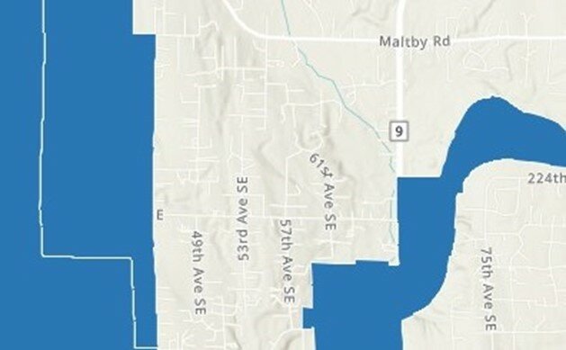
Map of part of Bothell’s Urban Growth Area, in blue. Map Data: USGS, EPA, Washington State Counties, Washington State Department of Ecology, Office of the Chief Information Officer-Geospatial Program Office, Washington State Department of Transportation, Esri, HERE. Powered by Esri.
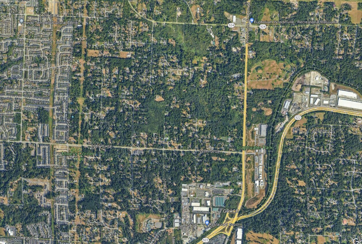
Aerial map of part of Bothell’s Urban Growth Area, showing a distinct division between urbanized land inside the UGA and forested land outside the UGA. Map Data: Google Earth imagery date: 8/23/2022
Whether Thurston County will do the same is uncertain. Developers own 46 acres at the corner of 93rd Avenue and Old Highway 99. The parcel contains 33 acres of forestland that was logged in 2011 and densely replanted with Douglas-fir and western white pine, and the trees are now 30-feet tall. Developers want to bulldoze over it. But they can’t do that unless they can convince the county to put it into the Tumwater Urban Growth Area. They want the county to use the new UGA swap law to do this.
If the developers succeed with the rezone, they say they will build multiple apartment buildings, a grocery store, office buildings, storage facilities, a YMCA, and a “community center.” It is hard to say no to a new YMCA, to be sure. That is probably why developers thought to include it: it distracts people from the downsides. But a YMCA can be built anywhere zoning allows it. By contrast, once forestland is bulldozed and built on, you can never get it back. Urban sprawl is irreversible.
Last year, county staff went all around Thurston County and asked community members what their vision is for the county. Preserving rural character and a healthy environment were two of the top responses. If you care about trees and climate mitigation, tell the county you want it to hold the line and deny this proposal. Go to Comprehensive Plan Docket 2024-2025 Update - Public Comment Form Survey (surveymonkey.com) and check the box for “Bar Holdings UGA Swap.” Your comments are due before this Thursday, March 14, at 5:00 p.m.
Misinformation Campaign
Recently, the developers of the proposed rezone mailed a brochure to many landowners in Thurston County to encourage them to post comments in support. The brochure featured many examples of greenwashing. “Greenwashing” is the act of making false or misleading statements about the environmental benefits of a product or practice. For example, the brochure described the developers as benevolent and claimed that the development would reduce vehicle trips in the area. But adding apartment buildings far away from the urban core means you’re making people drive farther to get to work. That means more emissions from daily commutes.
The most troubling aspect is the way the brochure co-opted the Squaxin Island Tribe. The parcel is located on the Nisqually people’s traditional lands. If approved, the development would pave over a remnant of an ancient Native American trade route called the Cowlitz Trail, as discussed below. To counter the bad comments the proposal has already received in this regard, the developers reached out to the Squaxin Island Tribe (but not the Nisqually Indian Tribe) and promised to “celebrate indigenous architecture with historical narratives.”
In return for this promise to put up placards, the developers put the logo of the Squaxin Island Tribe prominently on the brochure and claimed that the project has “garnered tremendous backing” from the tribe, among other entities. But nothing holds the developers to their promise of placards, or to any other promise, for that matter. Once the land is rezoned, there is no guarantee that the development will occur as proposed. The developers could build anything they want within the allowed uses of the rezone.
What Is the UGA Swap Law
Before the UGA swap law came into effect, counties were not allowed to put more land into the UGA unless the UGA had run out of land to build on. The UGA swap law changed this by creating another option. Counties can now put land into the UGA by taking other land out of the UGA. The idea is to swap out land from one part of the UGA to preserve it, in return for swapping land into the UGA in another area where there is development pressure.
A Domino Effect
The UGA swap law may seem good at first glance, but the development in this case doesn’t meet its criteria. Under the new law, a swap is allowed only if the area where a county plans to swap land into the UGA is running out of space. The UGA at the swap-in location essentially must be bursting at the seams. But the developers in this case admitted the opposite in their application. They described the area of the UGA near the corner of 93rd and Old Highway 99 as having 61 acres of “underdeveloped” land.
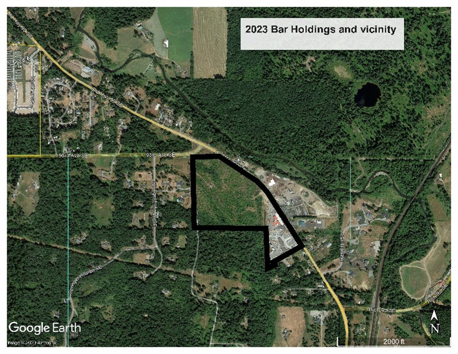
Aerial map showing the vicinity of the 33 forested acres that the developers want to put into Tumwater’s Urban Growth Area so they can build apartment buildings, a large grocery store, storage facilities, office buildings, a YMCA, and a “community center.” Map data: Google Earth, ©2023 Airbus.
What’s more, putting their 46 acres into the UGA to build a mini-city would put development pressure on natural resource lands and rural lands. This is strictly forbidden under the swap law. If the commissioners approve the development, this will create a domino effect with rural lands being developed over time in an ever-expanding swath of urban sprawl.
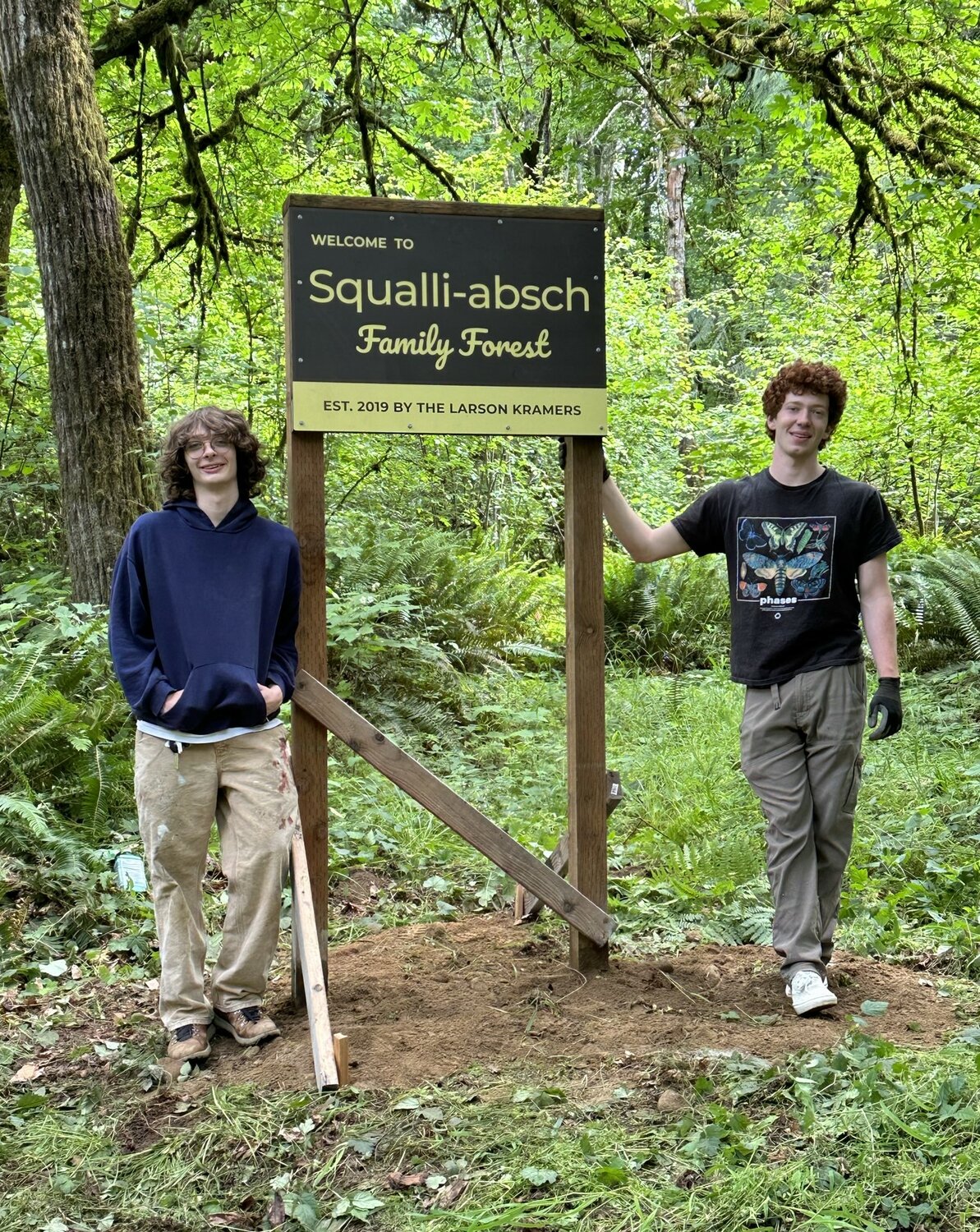
Not only are 33 acres of their parcel completely forested, but the parcel is surrounded by hundreds of acres of forestland. My family has owned 20 acres of forestland on the southern border of the parcel for 53 years. We named our forest “Squalli-absch Family Forest” (for the traditional name of the Nisqually people) in honor of Chief Leschi. We have been planting hundreds of trees there and are putting it into a working forest conservation easement with the Capitol Land Trust.
The proposed development is also adjacent to the Deschutes River and hundreds of acres of timberland and preserved lands to the northeast. To the west and southwest of the parcel is the Springer Lake neighborhood, which is mostly trees with one house every five acres. The Capitol Land Trust has conservation easements on several of the parcels there.
Not a Balanced Swap
Even the land the developers want to swap out of the UGA wouldn’t gain any protection under their plan. The proposed swap-out parcels are floodplain wetlands and under power lines. Federal law prohibits urban development under power lines. And building at urban densities in floodplain wetlands would be cost-prohibitive due to legal constraints. Therefore, swapping the parcels out of the UGA would do nothing in terms of natural resource protection. Those parcels are already protected from urbanization.
Big Carbon Footprint
One thing to know about urban sprawl is that it has a big carbon footprint. When you cut down a forest to build apartment buildings, you are removing carbon sinks. And when you put multi-family housing on the outskirts of town, you’re increasing miles driven to work every day. This is inconsistent with Thurston County’s Climate Mitigation Plan.
The developers claim their proposal would be carbon friendly because building a new grocery store there would reduce shopping trip distance for residents who already live in the area. But people drive to work a lot more often than they drive to the store. Putting a lot of new housing far away from where people’s jobs are is going to increase emissions, not decrease them.
What’s more, a plethora of shopping options are nearby already. Spuds grocery store is right around the corner, and next to it are vacant storefronts waiting to be filled. Only a ten-minute drive away are Costco, Walmart, Fred Meyer, Home Depot, and Safeway.
The Proposal Threatens an Archaeological Site
As mentioned, the parcel that the developers want to pave over has a remnant of the Cowlitz Trail. This was an ancient Native American trade route that later became a spur of the Oregon Trail. It could be more than 9,000 years old.
And the parcel is unique for another reason, although a sad one. In 1869, the parcel was practically the spoils of war. After the Medicine Creek Treaty, Chief Leschi of the Nisqually people was wrongfully convicted of murder and executed in 1858. He was later exonerated by the Washington Supreme Court in 2004. The sheriff’s deputy who kicked the pin from the trap door on the gallows was a young man named William H. Mitchell. Eleven years after Mitchell carried out the execution, Mitchell bought property that included this parcel.
In this way, a parcel that had been part of the Nisqually people’s traditional lands came into the hands of their chief’s executioner. Rather than promising the Squaxin Island Tribe to put up placards that discuss indigenous architecture, the developers would be better off honoring Chief Leschi of the Nisqually Tribe by not bulldozing a remnant of the Cowlitz Trail.
Olympia & Tenino Railroad
Not only did the Cowlitz Trail traverse the property, but so did a railroad with an interesting history. In the late-1800s, the company building the first transcontinental railroad did an about face and chose Tacoma as the railroad’s terminus instead of Olympia. The Olympia business community felt like the rug had been pulled out from under them. It meant a massive lost opportunity for economic growth.
Mitchell was by then a prominent Olympia businessman. He and others decided to create a railroad company of their own. Mitchell donated part of the parcel for the path of the new “Olympia & Tenino Railroad.” It ran for 40 years and was abandoned in 1916. The map below shows the path of the railroad through the property, as well as the Cowlitz Trail.
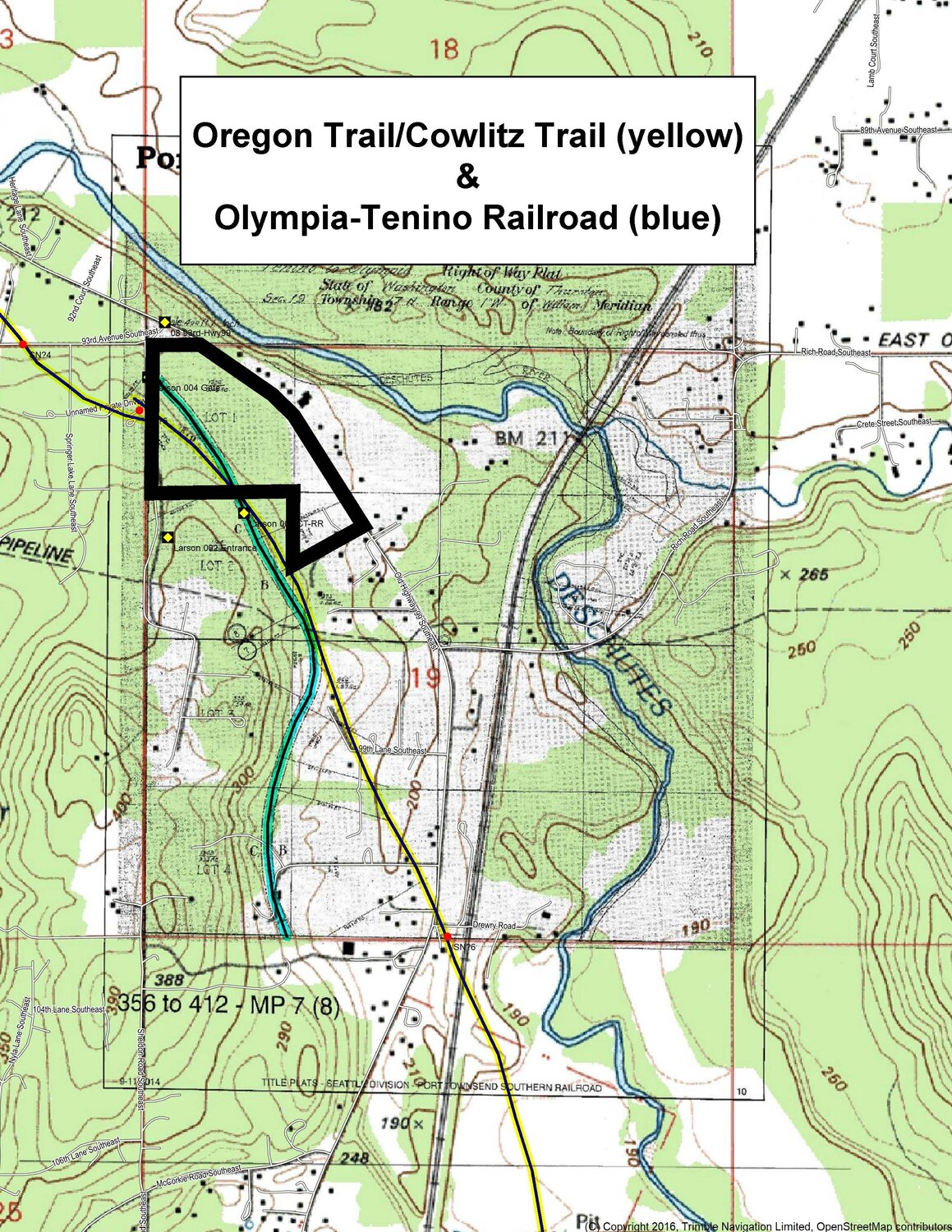
Map showing the path of the Olympia & Tenino Railroad (blue line) and the 1853 surveyed points of the Cowlitz Trail (red dots) with the surveyor’s estimate of the location of the Cowlitz Trail in between those red dots (yellow line). Adapted by permission from a map overlay created by Oregon Trail historian David Welch.
Thurston County Commissioners want your input on whether to allow developers to bulldoze over this forested parcel. Submit your comments by this Thursday, March 14, and ask the county to hold the line. We need to build up, not out.
~ Ronda Larson Kramer, Olympia
The opinions expressed above are those of the writer and not necessarily those of The JOLT's staff or board of directors. You're free to post your response below. Otherwise, if you have something to say about a topic of interest to Thurston County residents, send it to us, and we’ll most likely publish it. See the Contribute your news button at the top of every page.


8 comments on this item Please log in to comment by clicking here
wildnature
Very good explanation Ms. Kramer! My heart aches for your family. I took the survey you linked, and for everyone's information, where it asked: "Select Projects you wish to comment on" I want people to know it is the one called: "Bar Holding UGA Swap, Land Use Amendment and Rezone." It took me awhile to figure this out from the many confusing choices the survey offered.
Tuesday, March 12 Report this
Duffish
Let's utilized the UGA for what it is intended, not use it as a wedge for swapping other areas and encroaching on natural areas. The article above is well written and describes the losses that will occur if this land is developed. We need to be vigilant in protecting larger tracts of forested land and other cultural resources. The best way to do this is to provide public comment. If natural areas and vegetated tracts are not protected, we will lose our resiliency to battle increasing impacts from climate change and lose scarce cultural resources. Development should be occurring where the infrastructure is already there, not decentralization sprawl causing more pollution and further degradation of our beautiful county.
Tuesday, March 12 Report this
KellyOReilly
Thank you so much for this well-written opinion article on the Bar Holdings UGA Swap Rezoning proposal with links to submit public comment on it. I submitted my comment to the county opposing this UGA Swap. I hope they don't approve it.
Tuesday, March 12 Report this
Southsoundguy
Abolish democratic government control of land, it only leads to destructive urbanization.
Wednesday, March 13 Report this
RondaLarsonKramer
@southsoundguy, thanks for your comment and for caring about urban sprawl. I did want to note that Snohomish County appears to have done the opposite of destructive urbanization, as illustrated in my article with the photos of Bothell's UGA. Democratically run counties do have the ability to govern well in many circumstances, and Thurston County may very well make the right decision in this case. The jury is still out. If private industry (i.e., the developers) were in the decision-making positions, it would be virtually guaranteed that we'd have destructive urbanization eating up all our rural lands.
Wednesday, March 13 Report this
BostonHarbor469
Great article! Very good information and sad to hear what is proposed. Hopefully this will not be passed.
Wednesday, March 13 Report this
oldgar9
Too late for the survey, however, I'd like to say that we live in the EVERGREEN State, Not the asphalt state, Disasters like the bulldozing of Tumwater Hill should be kept in mind as we go forward.
Saturday, March 30 Report this
52237123abc
I suspect the City of Tumwater, Thurston Co. and the developer have done the same “land swap” with the Mazama Pocket Gopher. Just what they did on 79th to make way for their poorly placed Operations and Management facility. Good luck…..you’ll need it!
Saturday, June 15 Report this