Transportation Policy Board chair Andy Ryder and member Pete Kmet asked the Transportation Demand Management (TDM) program to explore the missing connections within the neighborhoods and identify areas that do not have safe sidewalks for walking to schools.
On Wednesday, February 8, Veronica Jarvis of TDM updated the board members on the recently completed School Walking Route Map project for North Thurston Public Schools (NTPS), Olympia School District (OSD), and Tumwater School Districts (TSD).
Jarvis said the project started in 2018 when the Thurston Regional Planning Council awarded a federal grant under Transportation Alternatives Program (TAP) to the three school districts to develop school walking route maps.
She said the project process includes coordinating with stakeholders - school principals, district transportation officials, city officials, county staff, intercity transit staff, school resources officers – who provided input to make safe walking routes for children to get to school.
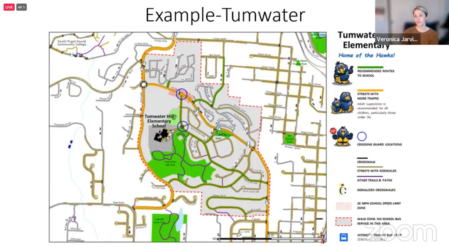
The walking route maps show:
Jarvis presented examples of some schools with updated maps that show recommended routes and other options.
Jarvis added that some schools in the region are non-walking schools. She said it means they have roads that are too busy or have no safe routes to walk.
“If you look at the walking maps that we did and [find no walking maps going to their school], it could be because it was a non-walking school for various reasons,” said Jarvis.
"If you have walked around our schools recently, there are many options. We identified the best and safest option," Jarvis added.
Discussion with stakeholders
Jarvis claimed they had good discussions with stakeholders that produced great results, adding that some projects were in transportation plans that may move up or be reprioritized. “We realized that they were impacting a vulnerable section of our community, young kids walking to school.”
Jarvis cited the path improvement on Carlyon Avenue going to Pioneer Elementary School. She described it as wrought with tree roots. Many people, including kids, were using that path.
“Olympia stepped up and smoothened that path and made it excellent for walking and biking,” Jarvis said.
She added that there are other transportation improvements made in Tumwater, such as updating speed limits on neighborhood streets to make them safer for students.
Ryder inquired if they identified areas that need sidewalks to have a safe route to school.
“I guess it shows on your map a little bit about the major gaps where we do not have a safe sidewalk on these walks to school,” commented Ryder.
"There are many places I know – certainly lower and upper Tumwater are not very well connected. I noticed that on one of the maps as well. It seems like that would be a logical follow-up as well to identify some of the missing connections and include them in the plans," Kmet, a former Tumwater mayor, commented.
Jarvis shared that they had yet to make additional requests to carry on the work relating to missing connections and sidewalks besides doing the maintenance plan.
"I think that would be an awesome project. I want to see the kids walk and roll the school as much as possible,” she said.
Jarvis said the school walk route maps would be sent to principals and partners and would request feedback by the end of May. The updated maps would be distributed to the school transportation directors for the upcoming school year.


Comments
No comments on this item Please log in to comment by clicking here