
Capitol Lake is the city’s highest risk for downtown flooding.
Olympia Water Resources Director Eric Christensen said this during the Olympia Sea Level Response Collaborative (OSLRC) meeting on Thursday, May 26, to update members on the SLR plan.
The City of Olympia, the Port of Olympia, and the LOTT Clean Water Alliance entered into an interlocal agreement to establish the Olympia Sea Level Rise Response Collaborative plan in 2017. The committee is supported by a technical work group.
“The plan addressed climate science, sea level rise projections vulnerability and risk, and strategies for adaptation along with their estimated costs,” Christensen said.
The plan envisioned a phased approach to comprehensive near-term, midterm, and long-term strategies for minimizing flooding.
According to Christensen, downtown Olympia has always been vulnerable to flooding.
“It is a result of the confluence of high water levels of Capitol Lake, and high tides in Budd Inlet. When those combine, marine water can spill over into downtown streets’ low-lying areas,” explained Christensen.
Christensen added downtown flooding is anticipated to become more frequent and severe in the future.
Melting mountains, expanding oceans
He said the International Panel on Climate Change (IPCC) recently published a special report on ocean and cryosphere in a changing climate.
“There were not many new findings, but the report reiterates that sea levels are rising globally,” Christensen reported, “with acceleration in recent decades due to continued glacier mass loss and ocean thermal expansion.””
Christensen cited the IPCC report indicating that the sea level continues to rise at an increasing rate and is projected to continue beyond 2100 or at the end of the century.
The sea rise level would increase approximately six inches in the IPCC's new projection. Their last prediction was in 2018.
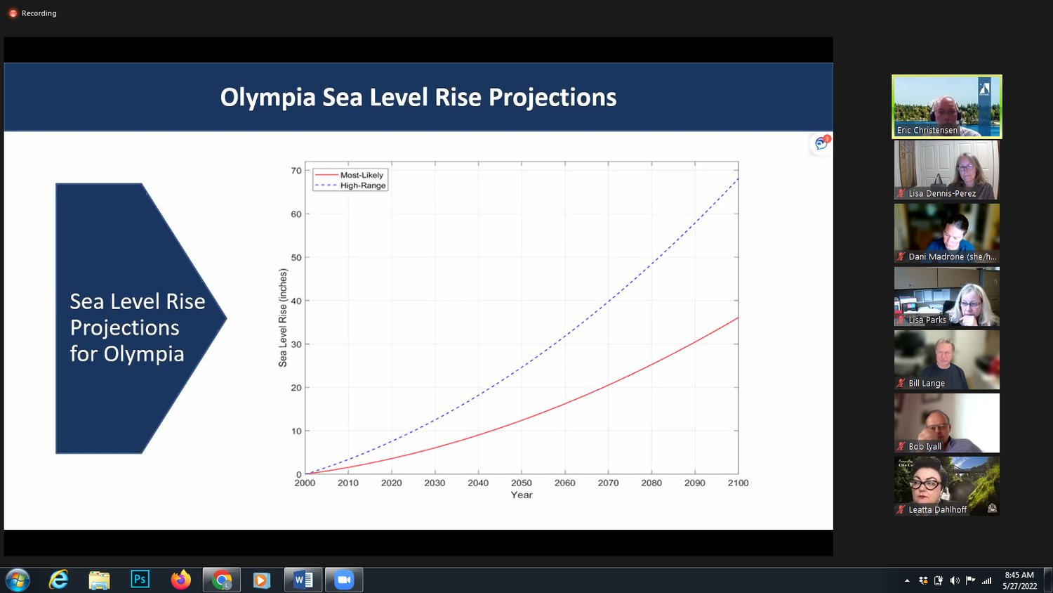
Christensen added that projections now range approximately between 17 and 33 inches by the end of the century.
Christensen shared that the OSLRC plan predicts between 36 and 68 inches sea level rise in Olympia in 2100.
“Human society needs to reduce greenhouse emissions urgently to prevent global warming,” warned Christensen.
He added the OSLRC plan projected the elevation in sea level would mean up to eight inches of land subsidence or sinking of the ground in Olympia.
On January 7, Christensen said Olympia experienced a 17.9-foot tide, the highest tide the city had experienced in more than 40 years.
The tide was predicted to come in at 16.46 feet, but it was associated with approximately 5.5 inches of rain in the previous two days. As a result, it reached 17.9 feet.
He said the high river flows and extreme tides jeopardized the streets, particularly on Water Street.
According to Christensen, the flood got up to the restrooms at Heritage Park.
The strategies recommended by the OSLRC plan include management of flood event emergency response, including backflow prevention on key stormwater outfalls and pipes and minor landscaping of low spots to lessen flood impacts.
“Even with these actions, low-lying areas within and adjacent to Heritage Park will remain vulnerable to flooding during infrequent, high-discharge flood events,” stated the plan.
Other strategies include:
Christensen suggested some strategies for a continuing collaboration between Olympia, LOTT and the Port of Olympia. These include:
Christensen said some strategies come with a price tag, such as installation of tide gauge, land subsidence survey, ground water study and hiring a consultant for public financing mechanisms.
He said the total costs for the strategy plan is $210,000.
According to Christensen, Olympia is proposing to cover 50% of those costs and asking the partners – LOTT and Port of Olympia -- to contribute 25% each.


2 comments on this item Please log in to comment by clicking here
northbeachcomm
The discussion regarding the rising levels of flood water because of climate change, has been on-going for decades. This discussion above does not included some issues raised before this. The Olympia City Council has given real estate tax breaks to the luxury condos now being built along Budd Inlet, Puget Sound. The City Council knows that this area will flood. Yet they expect us tax payers to now protect these luxury condos, these buildings. Many in the Olympia community have voiced these concerns since 2005. Tax payers do not want to pay to protect the developers who have chosen to take the risk of building next to Budd Inlet. Olympia City Council; Are you listening? Architect Ron Thomas boasts of his water front building projects, as he lines his pocket with money from the City and the Port of Olympia. Ron, your "fixes' for climate change impacts will not work! The City will flood. Tax payers will have to bail you out.
Tuesday, May 31, 2022 Report this
olyhiker
Flood? Really? I just wonder who decided to build City Hall and all those other new apartment buildings where they will flood. It was obviously a bad idea from the beginning.
Good letter, northbeachcom. You said it well.
Wednesday, June 1, 2022 Report this